Location Is Everything for Scooters
Micromobility—including electric scooters—is the latest quick and clean way to get around urban areas. But one big problem is managing where the fleets of shared scooters go and where they’re parked. Fantasmo has a solution—camera vision-based positioning. Fantasmo enables it by first mapping cities at the ground level, and then scooter riders use the camera on their phone to accurately record their exact position when it comes time to park.

A bit of history. When the first scooter fleets started operating in Santa Monica, California, riders took an end-of-ride photo that roughly placed their location. GPS was used to create a geofence in the city to say, keep scooters out of parks, but was not very accurate. When other cities started having scooter fleets, their biggest issues were bad parking and clutter and sidewalk riding. GPS mapping was too blunt of an instrument to monitor it effectively. Now, cities like San Francisco and Chicago simply require e-scooters to be locked to posts or signs to keep them out of the walkway.
Fantasmo’s technology solves this issue by providing the granularity to make accurate tracking of scooter parking possible. It will also come in handy for future applications, such as tracking delivery bots and use by the visually impaired.
Mapping the Key Cities
Fantasmo is a seven-year-old US-based startup that’s backed by investors including Unlock Venture Partners, Freestyle Capital, TenOneTen Ventures and LDV capital, among others.
The company recently partnered with major European micromobility operator TIER to map more than 85 cities through exclusive partnerships in Europe and the UK, including Paris, France and York, England.

I spoke with Jameson Detweiler, co-founder and president of Fantasmo, about his company and the software and hardware that make this possible. Educated at Drexel University in Material Science and Engineering, Jameson also has plenty of startup and leadership experience. He previously co-founded LaunchRock, an idea-launching product, was founder and CEO of GreenKonnect, a human-powered search engine for the green building industry, and he co-founded LED lighting startup Summalux.
Fantasmo began as Fantasmo Studios. They were looking for the technology to create augmented reality games like Pokemon Go, which superimpose the game onto your actual surroundings. But it soon grew into much more.
“We wanted to combine alternate reality games with machines to better understand the real world and how to assist humans,” said Jameson. “We decided to focus on the next generation of mapping technology.”
Building a Map from the Ground Up
Positioning from satellites (GPS) is used by many applications, but the problem in cities is that buildings, trees and other objects can block the view of the street. This causes inaccuracies when the signal bounces off of these objects. Fantasmo’s solution is to build a 3D map of cities at the ground level, collected using cameras and sensors similar to those found on EVs. Once a city is mapped, Fantasmo can determine someone or something’s position by pinning camera footage to that digital map using its Camera Positioning System (CPS)—an alternative to GPS.
“We can create a visual fingerprint from the surroundings, like a big QR code, and use advanced math to interpolate from the images,” said Jameson.
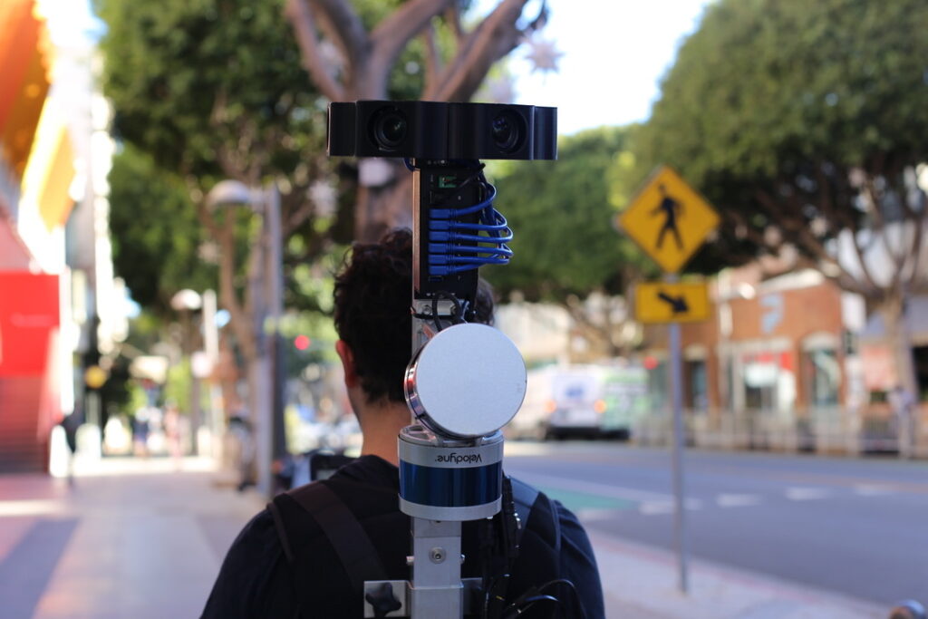
Fantasmo maps a city using the 22-pound Fantasmo Explorer backpack, which a Fantasmo employee wears as they walk down the sidewalks of the target city.

Fantasmo recently mapped 1,800 kilometers (1,118 miles) of Paris by foot, and is now working in York, with more cities on the way (under the TIER partnership). By taking the images from the sidewalk, it can target exactly where the scooters are at the end of a ride, when the rider uses their camera to take a few seconds of video images of the surrounding buildings.
The Paris project employed six backpacks, each shared by two people working shifts for a few weeks. The French capital enjoys high scooter usage, but limited sidewalk space, so it has designated 2,500 mandatory parking corrals for them. Fantasmo mapped these areas first and will eventually map the entire city.
A City on Their Back
The high-tech backpacks are set up with shoulder and waist straps, like good backpacking gear. They bristle with two lidar “pucks” and six cameras, like the ones used on autonomous vehicles, and are a little like micro-sized, wearable Google mapping cars. After a couple hours of training, the employees follow their assigned missions for the day, using iPads to communicate with the backpacks.
Now, when a French scooter rider is ending their ride, they will use the TIER app to scan the surroundings for a few seconds and the app tells them if they are in a designated parking area, to an accuracy of 20 cm (just under eight inches). If they are not, then they must move to one before they can end their ride. No physical infrastructure is needed.
Fantasmo manages the entire mapping project for a city for TIER or any other client. This means that they visit the target city and use their mission planning tool to draw the boundaries and create walking routes to cover the whole city. Once those routes are queued up, they can be assigned to the walkers. Fantasmo’s system monitors progress and can fill in any gaps that may occur.
Naturally, there are changes in a city over time, but the software can flag changes when riders use it, so new images can be taken, say, if a building is torn down. However, the initial backpack mapping creates a “substrate layer” that doesn’t need much updating. The images use solid, permanent items like a building’s windowsills, so changes in signage, for example, don’t affect the accuracy.
“It’s a dynamic situation,” said Jameson. “We recently had to skip mapping a section in York because it was flooded,” said Jameson.
Future Maps
Jameson sees the future in self-healing maps, and the use of data from more sources.
“For the next generation, any device can take images, masking out personal data, and create a digital twin of a city,” said Jameson. “This will be good for autonomous solutions for micromobility, pedestrians and cars.“

He also sees a time when the technology will live on the scooters themselves.
“We’ll know where the scooter is 100 percent of the time,” said Jameson. The scooters will be as smart as robots.”
Jameson believes that accurate positioning is a steppingstone to real autonomy in cities. Every device will be aware of itself, its location and other vehicles, scooters, bikes and people. Thanks to the shared mapping, it will be able to “see through buildings.” The goal is zero accidents and maximum efficiency. Fantasmo’s applications also work with mobile, auto and robotics, so there are lots of exciting things coming.
When will the company come home and start mapping American cities? There are plans, and Fantasmo will announce them when it’s time.
Autonomy and micromobility are essential to the health of our cities, and Fantasmo’s mapping technology is in the middle of it, making it happen.
Story by Steve Schaefer; photos from Fantasmo and Clean Fleet Report files.
Related Stories You Might Enjoy–More Micromobility News
Micromobillity: Behold—A Revolutionary Bike Helmet
Micromobility: An Electric Mercedes for One
Micromobility: Superpedestrian Creates a Better Scooter

I do agree with all the ideas you have presented in your post. Theyre very convincing and will certainly work. Still, the posts are very short for newbies. Could you please extend them a bit from next time? Thanks for the post.
You raise a good point, but it’s a challenge online. Many readers come for a quick-read and a short burst of information. We try to provide links to additional stories that give more information, but realize it’s tough to meet everyone’s needs in a single article. Thanks for reading and hope to see you back again soon. –Ed.